Contents


The Malaspina expedition
The 1789-1794 voyage of Malaspina and Bustamante, seeking to imitate and surpass those of Cook and Lapérouse, was with little doubt the most ambitious 18th-century scientific expedition. It explored the coasts of South America and sailed north along the Pacific coast all the way to Alaska, going on to visit the Philippines, New Guinea, New Zealand and Australia. It left behind an enormous wealth of scientific information, ranging from botanic catalogs to ethnographic accounts and very accurate coastal surveys. Although Malaspina’s comments could have paved the way to a renewed management of the Spanish dominions, the outcome of his expedition was kept from being published for political reasons, and did not fully see the light until decades -in some cases even centuries- later.
Until the 18th century, knowledge of the Northern Pacific was limited to the coast of California. Starting in 1774, Spain responded to the growing threat of Russian settlements in America and English and French expeditions by launching an unprecedented campaign for the exploration of the Pacific Northwest, which included voyages such as those of Pérez, Bodega y Quadra, Mourelle, Martínez and Alcalá Galiano. In less than two decades, the whole coast from Alaska to San Francisco had been discovered and surveyed; thus appeared on the map one of the last great uncharted regions of the world.

Bodega y Quadra, in his role as Commander of the Naval Department of San Blas, was tasked with coordinating Spanish expeditions to the Northern Pacific. This chart drawn by Quadra is a compendium of the progresses made in the exploration of the Pacific Northwest coast before the voyage of Malaspina.

The expedition set sail on board of the Descubierta and the Atrevida, two corvettes built specifically for the task. Corvettes were small warships, light and maneuverable, and smaller -but faster- than frigates. Virtually equivalent to British sloops-of-war, they were the ship of choice for 18th- and 19th-century explorers.

Malaspina, an Italian-born naval officer, explorer and scientist, served the Spanish Crown in the late 18th century. After his famous voyage, his outspoken criticism of Spanish colonial policies in America and association with a plot against Prime Minister Godoy caused his falling out of favor; he was imprisoned, and all accounts of the expedition were suppressed until decades later.

José de Bustamante was a Spanish naval officer, captain of the Atrevida and second in command in the Malaspina-Bustamante expedition. In the years after his return, however, his fate was better than that of his superior.

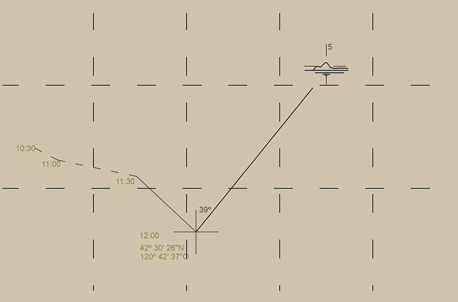
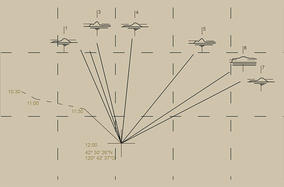
The Malaspina expedition included among its goals that of charting accurately the coasts that it visited, some of which were also being discovered for the first time. These pencil-drawn survey sketches of the coast of Alaska are triangulations of points on the coast as seen from the course of the expedition.

These sketches, intended as preliminary documents for the production of charts, offer us a priceless insight into 18th-century procedures for coastal survey, which could be carried out directly from the sea without any need for landfall.

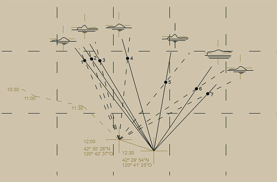
From the ship -the position of which had been established previously- a reference point on the coast was chosen. With the aid of a compass, the point’s direction was found and drawn on paper.
Surveying the coast
This process would be repeated for as many points as could be reliably identified.
Surveying the coast
The ship would then move to a different position. From this position, the same reference points would be located and their new direction found and drawn. The place where the two lines of direction met would represent the actual location of the point.
Surveying the coast
(Español) Una vez hallados todos los puntos, se puede dibujar a mano alzada la costa entre ellos.
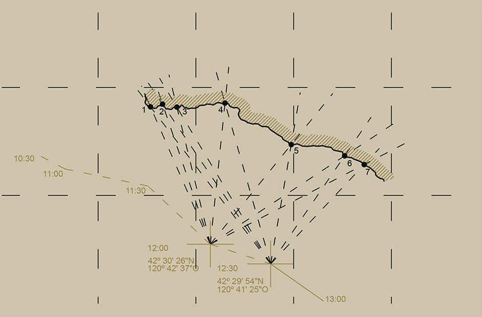
Surveying the coast
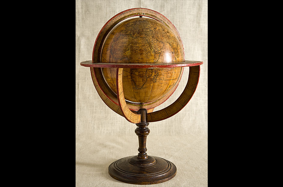
This, the oldest known Spanish-made globe, includes knowledge gathered from the Spanish expeditions of its day. The high accuracy of the Pacific Northwest coast, including information from voyages like Malaspina’s, is particularly striking.